Brighton Neighborhood Nodes
What is Neighborhood Nodes?
The Town of Brighton received a grant from the Wasatch Regional Front Council (WFRC) to fund and conduct the Brighton Neighborhood Nodes Design Plan. The purpose of the Brighton Neighborhood Nodes Plan is to examine, understand, and identify opportunities that will improve traffic conditions, future land use patterns, and overall experience of the Town of Brighton.
This plan focused on four areas (nodes) along Big Cottonwood Canyon: Cardiff Fork, Silver Fork, Solitude Resort, and Brighton Loop, and made recommendations for how they may be better interconnected to function without compromising their respective character.
Each node was identified as having distinct roles in Brighton’s ecological, recreational, and economic landscape. With Cardiff Fork and Silver Fork emphasizing the area’s historical and natural significance. And Solitude Resort and Brighton Loop serving as modern hubs for tourism, outdoor recreation, and community activity.
The plan solicited feedback from Brighton residents and conducted virtual open houses to get a sense of how people feel about various ideas in the node plan.
Node Concepts
The study identified opportunities and constraints with each node. To me the most intriguing concepts include:
Trail Connectivity
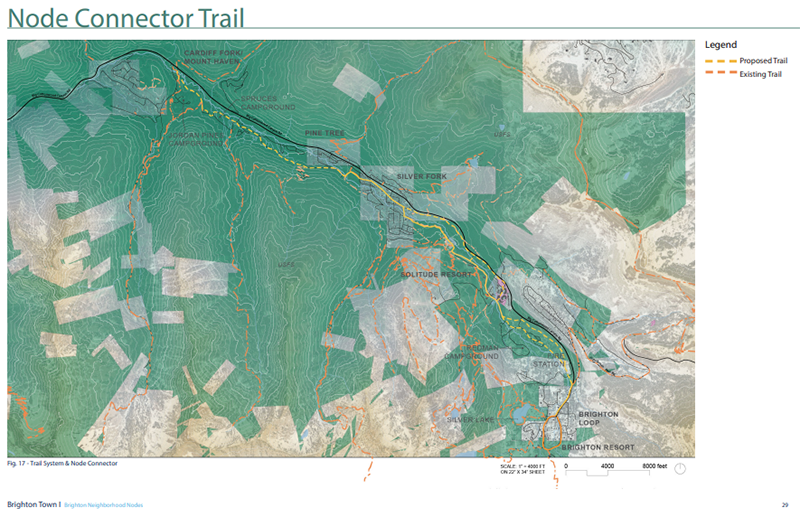
There was significant support for a “node connector” trail designed to establish a continuous connection between all four node areas, with a focus on accommodating bicycles and pedestrians.
Transit Hubs
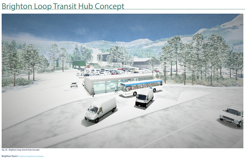
UDOT is currently planning to locate new transit hubs near Solitude village and the Brighton Loop. The plan is for the hubs to include amenities for patrons of the resort, including bathrooms, lockers, benches and amenities for those waiting for transit services. Additionally, the hubs will contain a bus loop with multiple bus bays to accommodate boarding/alighting and staging.
Dedicated Transit Lanes
The study proposes a dedicated lane for public transportation connecting Solitude Resort, Brighton Resort, and extending through the Brighton Loop, aimed at improving mobility and reducing reliance on single occupancy vehicles.
Civic Center
The plan identified potential properties suitable for a future civic center for the town. Public sentiment is split on the need for a civic center, but if one were developed the three most desired amenities, ranked in order of importance are: public meeting space, public restrooms, outdoor gathering space.
Nodes Implementation Timeline
Implementation timeline of the nodes project include the following phases:
The short-term phase (Years 1-2) emphasizes planning, stakeholder engagement, and small-scale improvements to address immediate needs, including safety enhancements and feasibility studies.
The intermediate phase (Years 3-5) focuses on the construction of critical infrastructure such as trail networks, transit solutions, and public amenities.
The long-term phase (Years 6-10) envisions the completion of all major projects.
Partnerships Needed
For the node concepts to become reality there is going to need to be collaboration and partnerships with residents, government agencies (e.g., UDOT, UTA and USFS), and private stakeholders (e.g., resorts & landowners).
Please share your feedback.