Proposed Ski Resort Boundary Maps Approved
Updated 10/17/25
At the October 15, 2025 Brighton Planning Commission meeting, there was a very positive development on defining the ski resort boundaries for Solitude and Brighton.
Meeting Summary
The Planning Commission reviewed an updated ski resort boundary map prepared by the Municipal Services District (MSD). This new, higher-resolution map included both Solitude and Brighton without materially changing the boundaries from the previous versions.
There was discussion about whether the Solitude Nordic Center should be treated as separate from the rest of the resort. Regardless of how that question is resolved it does not alter the overall ski resort boundary.
Representatives from both resorts, the public, Wasatch Backcountry Alliance, and Save Our Canyons provided input. The general public sentiment strongly supported the MSD’s proposed boundaries – with notable objections from Solitude Village residents who expressed a preference to not have their properties included within ski resort boundaries.
Ski Resort Input
Brighton Resort mostly agreed with the proposed boundaries, noting they do own a few private parcels that were not on the map. Brighton’s representative emphasized that their biggest concern is that the maps do not completely prevent future resort expansion onto private property.
Solitude objected to the maps, arguing that the official boundary should include both their Forest Service Special Use Permit area and their privately held parcels purchased under prior zoning rules. Solitude’s representative also raised concerns about the potential devaluation of private land and the risk to the town if its zoning or use restrictions were changed after acquisition of the property (click here for a transcript of ski resort public comments).
Commission Decision
After hearing all input, the Planning Commission voted unanimously to forward the MSD boundary maps to the Town Council with an affirmative recommendation, finding that they align with the goals of Brighton’s General Plan.
The Commission also recommended:
- Clarifying the treatment of the Solitude Nordic Center, either with a map notation or a text amendment.
- Grandfathering existing non-conforming uses (such as the Roundhouse Lodge) as conforming.
Before the vote, commissioners eloquently noted that both Solitude and Brighton are valued partners and vital parts of the local economy and recreation culture. This action wasn’t about limiting what may happen in the future – it was about providing a starting point and process for the Town Council to engage with the resorts on development of land outside the resort boundaries
What Happens Next
The decision now moves to the Brighton Town Council, who will decide whether to formally approve the MSD resort boundary maps.
If approved, the property on Old Stage Road would remain outside Solitude’s official resort boundary, meaning it cannot be used as a ski resort support facility (such as a parking lot) unless the Town Council later votes to expand the boundaries. At this point, such an expansion appears unlikely.
Solitude and Alterra have several response options moving forward. My hope is that they choose to work collaboratively with the town to address transportation needs while exploring establishing a conservation easement that permanently protects the Old Stage Road property.
In recent correspondence, Solitude suggested that the reduced development potential of the property could raise legal questions about loss of value. However, unless the Town of Brighton made prior assurances – which to my knowledge it did not – those legal risks were assumed by Solitude at the time of purchase.
If Solitude concludes the property no longer holds development value, it could present an opportunity for the town and/or private partners to acquire the land and permanently protect it from future development.
Note: the following update on the MSD proposed ski resort boundary maps was posted prior to the October 15 Planning Commission meeting
Proposed Ski Resort Boundary Maps Released
Updated 10/15/25
Current Status of Old Stage Road Parking Lots Proposal
The question of whether the parking lots can be approved now hinges on the location of the ski resort boundary lines. For background, please see the Planning Commission’s September meeting update.
There are currently multiple conflicting maps of the ski resort boundaries. To resolve this, the Planning Commission tasked the Municipal Services District (MSD) with creating definitive boundary maps for Solitude and Brighton, incorporating input from the US Forest Service, the Salt Lake City Department of Public Utilities, and the resorts themselves.
On October 10, an updated Planning Commission meeting packet was released featuring the MSD’s proposed maps. While the maps include input from the Forest Service and SLC Department of Public Utilities, Solitude cited scheduling conflicts and requested the item be continued for another month to allow time for meeting with MSD staff.
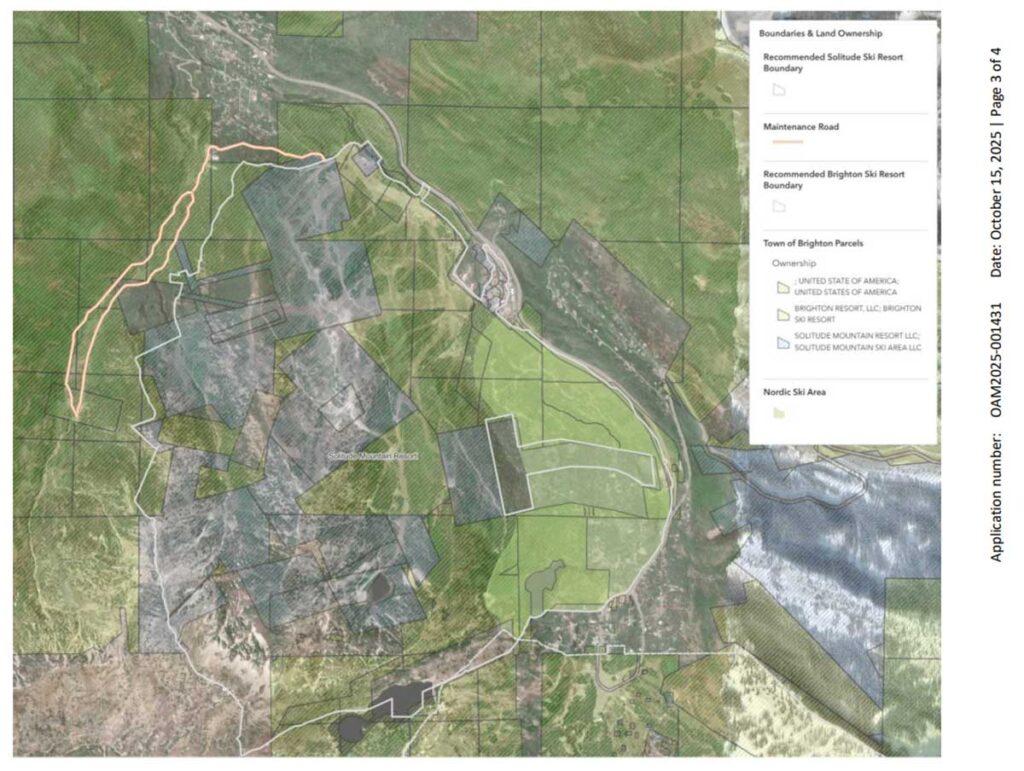
The MSD’s proposed maps are good news for opponents of the parking lots! The Solitude boundary, as proposed, excludes the Old Stage Road and Guardsman Pass/Hidden Canyon properties. If the Solitude map is adopted, the proposed Old Stage Road parking lots would be considered a prohibited land use.
The Solitude Boundary Map
Below is the MSD ski resort boundary map for Solitude:
Without clear reference points, the MSD map is difficult to visualize. Below is an updated version I’ve created, featuring chairlifts, labels, and a more prominent boundary line.
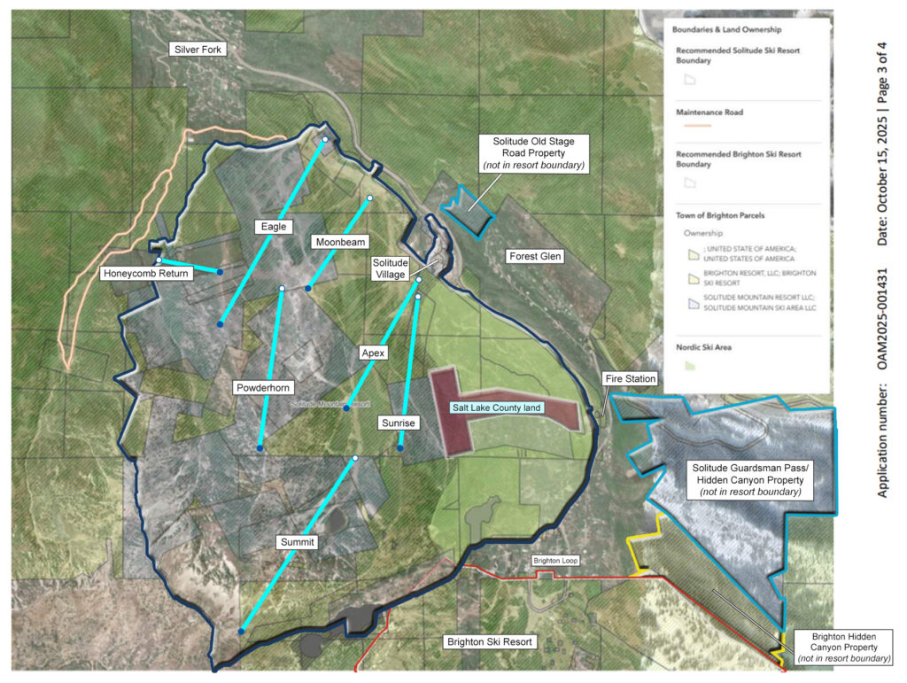
The MSD’s proposed boundary makes sense: it includes Honeycomb Canyon, the inbounds terrain served by all chairlifts, and encompasses the Nordic trails, extending up to the fire station, Nordic Center, and the edge of the Brighton Loop. By any reasonable measure, this accurately reflects the operational footprint of Solitude Resort.
Key takeaways:
- The entire Solitude ski resort boundary lies south of SR-190
- Solitude’s Old Stage Road property is not within the ski resort boundary
- The non-contiguous Guardsman Pass/Hidden Canyon parcel is outside the resort boundary
- Most of Solitude Village is included, but some condos and single-family homes fall outside the boundary
- The Giles Flat neighborhood appears to be excluded from the boundary
- The boundary at Entry #2 meets SR-190, roughly 250 ft from Solitude’s 7080 S. Old Stage Rd. and 500 ft from 12202 E. Old Stage Rd. properties
- There is a large carveout within Solitude’s boundaries on the east side. This is Salt Lake County land (the mapped shape doesn’t perfectly match assessor records but it looks to be approximately 50 acres in size)
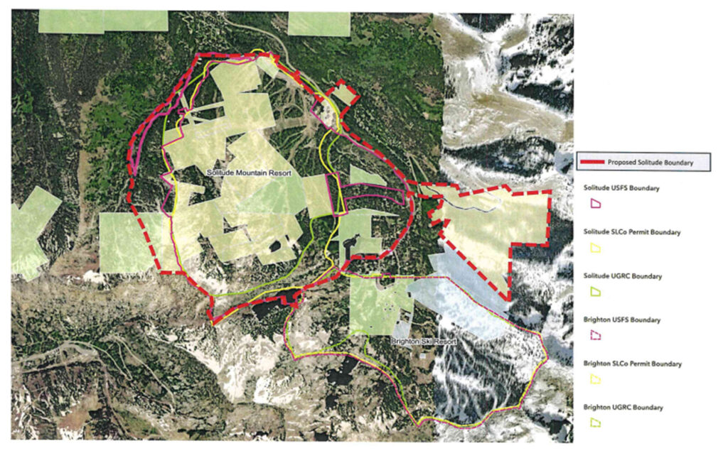
Solitude Submits a New Map
In a letter dated October 13, 2025, Solitude Mountain Resort submitted a new proposed ski resort boundary map to the Brighton Planning Commission:
In its letter to the Planning Commission, Solitude stated:
“A map that describes the resort lands should describe all of its lands. Solitude purchased and operates its lands in reliance on the codes that existed at the time of their acquisition and use.”
I disagree with this claim. The Town of Brighton never assured Solitude that its properties along Old Stage Road or Guardsman Pass/Hidden Canyon would qualify for unrestricted ski resort uses at the time of purchase. Solitude (and its parent company, Alterra) assumed the land-use risk, not the town.
The letter also argues that the Roundhouse Lodge at mid-mountain should not be rendered non-conforming. I agree that it’s fair to grandfather the Roundhouse to make it fully conforming; however, that issue has not been the primary concern. The real issue is the proposed parking lots on Old Stage Road.
Key takeaways from Solitude’s proposed map:
- The proposed resort boundary includes the entirety of Solitude Village and Giles Flat.
- The boundary extends across SR-190 to include all of Solitude’s Old Stage Road property.
- The boundary also crosses SR-190 just before the fire station, encompassing over 200 acres of Solitude’s property in Guardsman Pass and Hidden Canyon.
The Brighton Boundary Map
Below is the MSD ski resort boundary map for Brighton Resort, followed by a version with added reference points.
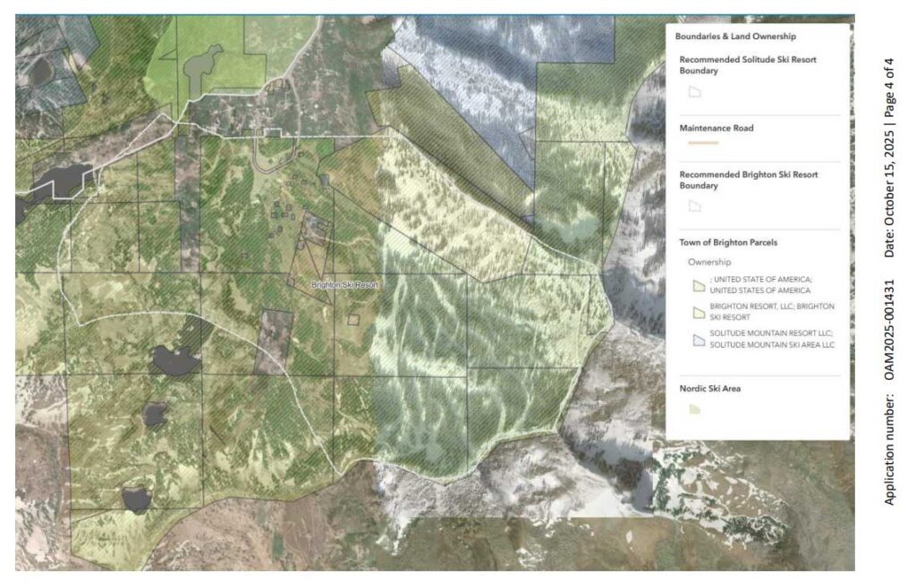
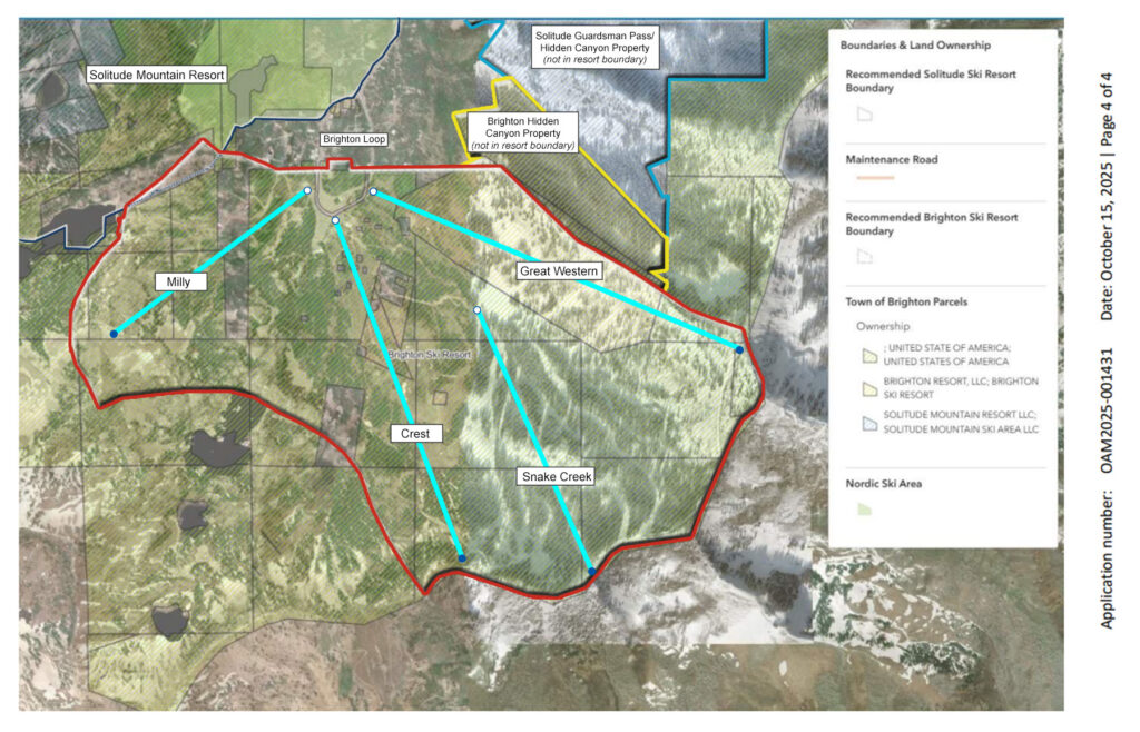
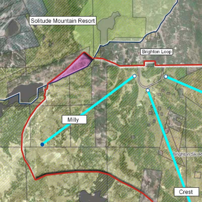
The proposed MSD map aligns closely with what most people recognize as Brighton’s boundaries. The western edge follows the SolBright trail and includes the Milly lift, then extends east through Crest, Snake Creek, and Great Western terrain.
Key takeaways:
- Slightly less than half of the Brighton Loop lies within the ski resort boundary
- The northeast boundary includes Elk Park Ridge towards the base of Great Western, but excludes the drop-off into Hidden Canyon
- Brighton’s property in Hidden Canyon is outside the ski resort boundary
Confusion on the SolBright Trail
The MSD boundary maps for Solitude and Brighton show an odd overlap along the SolBright Trail below the Twin Lakes dam. It’s unclear whether this overlap was intentional or an oversight by MSD staff.
Is This the End of the Old Stage Parking Lot Proposal?
If the Brighton Planning Commission adopts the ordinance amendments and the MSD’s proposed ski resort boundaries, it would mark a major victory for opponents of the Old Stage Road parking lots.
However, Solitude still has several potential avenues to pursue the project, so this is likely the end of the beginning, not the end of the fight. Continued public engagement and opposition remains essential.
This is genuinely good news though and a major step in protecting the canyon and moving Big Cottonwood toward sustainable, long-term transit solutions.
Click here to go to Old Stage Parking Lot Essay.