Tri-Canyon Trails Plan
Overview
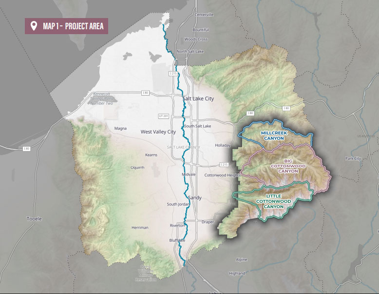
The Tri-Canyon Trails Plan is a comprehensive trail plan for Little Cottonwood, Big Cottonwood, and Millcreek Canyons that has been in the planning process since Summer 2020. The Tri-Canyons Trails Plan is currently in the final stage of planning and moving into the implementation phase.
The purpose of the plan is to identify specific actions needed to protect watershed health and provide diverse recreation opportunities in Big Cottonwood, Little Cottonwood, and Millcreek canyons. the Tri-Canyon Trails Plan directly shapes the future of recreation, watershed protection, and community in Brighton and Big Cottonwood Canyon.
Salt Lake County Parks and Recreation is currently updating its Regional Trails Master Plan, and the inclusion of the Tri-Canyon trail network is vital to making it comprehensive. The Salt Lake Ranger District is following direction in its Wasatch-Cache National Forest Plan, to evaluate the existing trail system (including user-created trails) to develop the Tri-Canyon Trails Plan.
Planning Authority
The Forest Service holds the final decision-making authority in the planning process. Both Salt Lake County and the Town of Brighton are working closely with the Forest Service so they may adopt sections of this plan that fall within their boundaries. A shared goal is collaboration – with local governments, partners, and stakeholders, to establish support and momentum for this plan.
Town of Brighton Engagement
It is important for the Town of Brighton to remain heavily engaged with the Tri-Canyon Trails Plan for several key reasons: protection of the watershed and natural resources, long-term sustainability, collaboration and local control, management of recreation and visitor impacts.
Implementation
The Tri-Canyon plan outlines three general implementation phases for trail projects, but definitive timelines for completion are not yet available:
Phase 1: Readiness for implementation. This phase includes projects that are most prepared to move forward. They may have already completed, or are soon to undergo, environmental assessments and scouted trail alignments. The Tri-Canyon Trails Team is expected to advance these projects first.
Phase 2: Complex projects. These are projects that require more detailed and time-consuming planning before construction can begin. This includes addressing issues like securing access over private land, getting engineering support, or scouting more complex trail alignments.
Phase 3: Long-term implementation. This phase is for projects that will be implemented as needed, potentially in concert with other large-scale, concurrent projects in the area. Other factors, such as changes in recreation levels or resource impacts, may also trigger the start of a Phase 3 project.
Big Cottonwood Canyon Trails
PHASE 1, BCC – BRIGHTON AREA
LAKE MARY – MAJESTIC LIFT CONNECTION: Design a sustainable, contouring, family-friendly trail connecting the Majestic Lift with Lake Mary. Close and restore user-created trails.
LAKE MARY TRAIL: Reroute the start of the trail away from the Alpine Rose. Reroute steep sections with more sustainable grades. Overall the trail should provide easier grades to an engineered hardened destination. Close and restore user-created trails.
TWIN LAKES – SILVER LAKE CONNECTION: Improve existing trail to be easier; reduce trail grades, improve tread, remove large obstacles, engineer hardened destinations.
BRIGHTON ALPINE TRAILS: Coordinate with Brighton Ski Resort to design and connect sustainable Forest Service and user-created alpine trails (Clayton Peak Trail, Big Cottonwood Mine Loop), ridgelines, and peaks, which may some day be accessible by ski lifts (Crest, Snake Creek, Great Western).
CATHERINE LAKE LOOP: Design a sustainable trail around Lake Catherine to protect the watershed and lakeshore vegetation. Close and restore user-created trails
LAKE MARY LOOP: Design a sustainable trail around the highly visited half of Lake Mary to protect the watershed and lakeshore vegetation. Close and restore user-created trails.
PHASE 1, BCC – DONUT FALLS AREA
DONUT FALLS BRIDGE: Install bridge over creek. May require a different location than previous bridge.
DONUT FALLS TRAIL: Reroute the trail out of the water to reduce impacts to watershed and shoreline vegetation. Design a wide trail with moderate grades to an engineered hardened destination (reduce waterfall climbing). Close and restore old trail and user-created trails.
CIRCLE ALL PEAK Formalize a short, sustainable trail providing a desired summit recreation opportunity. Close and restore user created trails.
PHASE 1, BCC – DESOLATION LAKE AREA
DESOLATION LAKE LOOP Design a sustainable trail around Desolation lake to protect the watershed and lakeshore vegetation. Close and restore user-created trails.
WILLOW LAKE LOOP Design a sustainable trail around Willow Lake to protect the watershed and lakeshore vegetation. Close and restore user-created trails.
PHASE 2, BCC – BRIGHTON AREA
BRIGHTON LAKES TRAIL REROUTES: Improve trail alignment with sustainable grades, remove the trail from wet zones.
BRIGHTON BASE – TWIN LAKES CONNECTORS: Design sustainable trails to provide access to Brighton Lakes from the parking lots at Brighton (Lake Mary Trailhead and Milly Base area)
LAKE MARY – LAKE MARTHA CONNECTOR: Design sustainable trails connecting Lake Mary, Lake Martha, and Forest Service trails.
SOLITUDE LAKE LOOP Design a sustainable trail around Lake Solitude to protect the watershed and lakeshore vegetation. Close and restore user-created trails.
TWIN LAKES LOOP Design a sustainable trail around Twin Lakes to protect the watershed and lakeshore vegetation. Close and restore user-created trails.
PHASE 2, BCC – BIG COTTONWOOD TRAIL
BUTLER – MILL D NORTH CONNECTOR: Design a sustainable trail connecting Butler Fork and Mill D North trails.
MILL D NORTH LOOP Design a short loop trail with easy grades, connecting to a spur trail leading to an old mine.
BEAR TRAP REROUTES Design a sustainable top section of the trail from its connection with the Wasatch Crest Trail.
SPRUCES – CARDIFF CONNECTOR Design sustainable easy to moderate trail connecting the campground with desirable recreation opportunities in the Cardiff Boardwalk area.
PHASE 2, BCC– MILL B AREA
BLANCHE LAKE TRAIL REROUTES: Reroute steep, rocky sections with sustainable grades.
BLANCHE LAKE LOOPS: Design a sustainable trail around the lakes to protect the watershed and lakeshore vegetation. Close and restore user created trails.
GRANITE FLUME LOOP: Design sustainable trail loop utilizing sections of the Granite Flume Trail. Close and restore user-created trails
HIDDEN FALLS (MILL B): Design short trail out of water from the Mill B north road crossing to the waterfall with an engineered destination.
MILL B NORTH OVERLOOK: Formalize a short, easy-grade trail to an engineered hardened destination (overlook). Close and restore user-created trails.
PHASE 3, BCC – UPPER BIG COTTONWOOD
BCC TRAIL – SILVER FORK TO MILL D: Design a sustainable trail with easy grades connecting Silver Fork, Spruces, Cardiff Meadow, and Mill D. Coordinate with landowners.
BCC TRAIL – SOLITUDE TO SILVER FORK: Design a sustainable trail with easy grades connecting Solitude and Silver Fork. Coordinate with landowners.
BRIGHTON TO WASATCH CREST (LOWER TRAIL): Design a sustainable bike trail to connect lower Brighton (Lake Mary Trailhead) to the Wasatch Crest.
BRIGHTON TO WASATCH CREST (UPPER TRAIL): Design a sustainable bike trail to connect upper Brighton (Majestic Lift area) to the Wasatch Crest.
WASATCH CREST – WILLOW HEIGHTS – SOLITUDE: Design a sustainable mountain bike trail with moderate grades connecting the Wasatch Crest, upper Willow Lakes, and Solitude. Help reduce traffic on Guardsman Pass, by providing new loop and access points. Verify property ownership and necessary easement.
WILLOW LAKE – SOLITUDE CONNECTOR: Phase with Big Cottonwood Mobility Plan. Connect a major trailhead (hub) to the popular Willow Lakes. Design wide, sustainable trail with easy grades. Coordinate with Solitude Resort and UDOT on possible highway crossing options.
BCC TRAIL – BRIGHTON TO SOLITUDE: Design a sustainable trail with easy grades connecting Brighton, Silver Lake, Redman, and Solitude. Coordinate with landowners.
OLD STAGE ROAD – SCOTTS CONNECTOR: Design a sustainable mountain bike trail connecting the Old Stage Road and Scotts trail, which will provide additional access to the Wasatch Crest.
PHASE 3, BCC – LOWER BIG COTTONWOOD
BIRCHES – LEDGEMERE – DOGWOOD CONNECTOR: Design a sustainable trail with easy grades connecting Silver Fork, Spruces, Cardiff Meadow, and Mill D. Coordinate with landowners.
BST – HEUGHS TO DOGWOOD: Continue to implement sections of the BST – a mixed-use recreation trail connecting the Wasatch Front. Connection with Granite Flume section needs a sustainable trail with easy to moderate grades. It’s south-facing, lower-elevation trails provides cold weather hiking options. Granite Flume connection needs bridges, engineering support, and historical review. Close and restore user-created trails.
MULE HOLLOW: Phase with trailhead improvement. Coordinate with Salt Lake Climbers Alliance on community needs. Formalize a sustainable trail with medium to steep grades to reduce erosion and provide desired recreation experience. Close and restore user-created trails
STAIRS GULCH: Phase with trailhead improvements. Coordinate with the Salt Lake Climbers Alliance on community needs. Formalize a sustainable trail with medium to steep grades to provide a desired recreation experience. Close and restore user created trails.
STORM MOUNTAIN LOOP: Coordinate with concessionaire and trailhead improvements. Design a loop hike around the meadow on a wide trail with easy grades. Close and restore user-created trails.
STORM MOUNTAIN OVERLOOK: Coordinate with concessionaire and trailhead improvements. Design a wide trail with moderate grades to an engineered hardened destination at the viewpoint. Close and restore user-created trails
Please share your feedback.